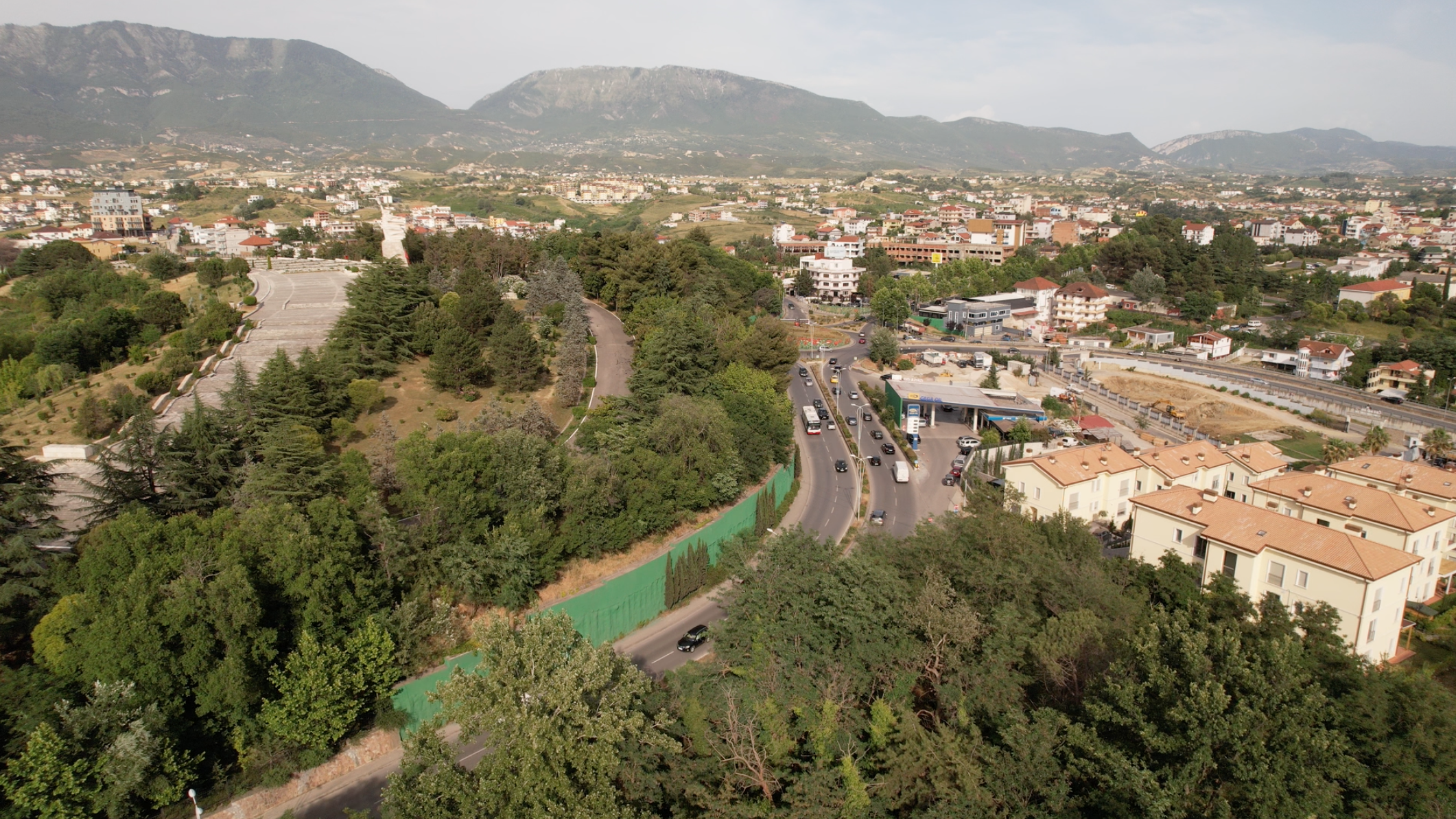
» Tirana’s rapid expansion over the past three decades has come at the expense of many of the green areas once surrounding it. The challenge to provide recreational space and venues for outdoor activities is significant and AADF is helping by considering ecofriendly and sustainable models successfully proven elsewhere. «
The AADF Annual Report 2022 – ↗️
urban trails – the Feasibility Study, performed by urban move, on behalf of the Albanian-American Development Foundation AADF

Project Principles
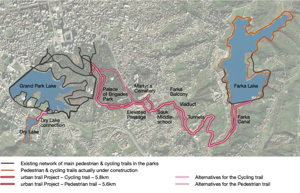
The project aims to build green paths and trails that link the Grand Park of Tirana with Farka Park and the Dry Lake neighborhood. These trails will not only provide avenues for recreation and relaxation but also contribute to the sustainable development of the region by promoting active mobility and preserving green spaces. To achieve this, the project adheres to strict guidelines ensuring the safety and accessibility of the trails.
The designed trails do not share the space with existing motorized traffic routes. They either follow newly established paths or reactivate previously abandoned routes. Streets with significant traffic loads will be safely crossed using overpasses, while at other intersections, maximum safety measures, such as traffic calming measures, will be implemented Well-lit pathways, limited gradients suitable for cycling, and the creation of attractive passages with clear route guidance and visibility help to also increase safety and security. Additionally, equal treatment for cyclists and pedestrians (in terms of quality and quantity) is prioritized, with each trail segment designed to be a spacious 4 meters wide, fostering a harmonious coexistence and encouraging diverse usage patterns.
Furthermore, the project emphasizes the importance of fostering synergies and creating new business opportunities within the community. By connecting green areas through the most direct routes, including the (still restricted) area of the Palace of Brigades Park, the trails aim to enhance the overall livability of the area. Through intuitive design and careful planning, the urban trail project seeks to not only fulfill its functional objectives but also contribute to the cultural and economic vitality of the city and ultimately becoming a cherished asset for residents and visitors alike.
The existing trail network has not undergone thorough examination, and there may be areas requiring improvement to ensure consistent quality throughout.
Route Proposal
In the process of route planning and design, the following factors have been considered:
- Connectivity: Establishing a network of trails to link the Grand Park Lake, Farka Lake and the Dry Lake as key destinations, including the surrounding parks, cultural sites and attractions, and the neighboring residential areas.
- Accessibility: Ensuring the trails are accessible to pedestrians and cyclists of all ages and abilities, with provisions for ramps, crosswalks, recreational spots, and other amenities like shading and lighting.
- Safety and security: Implementing measures to enhance safety, such as overpasses to crossroads with considerable traffic volume, respectively traffic calming techniques where crossing on street level is inevitable, signage, and lighting along the trail routes.
- Integration: Integrating the urban trail network with existing sustainable mobility infrastructure, including pedestrian paths, bike lanes, and public transport systems.
The highlights
The new pedestrian and cycling trails connect at the highest point of the Grand Park (Exercise Park) with the existing path network. From there the trails enter the (so far restricted) area of the Palace of Brigades Park through the north gate (in case the Palace of Brigades Park cannot be accessed [yet], an alternative bypass-route has been studied to be drawn along the Elbasan Road). There, in most parts, the existing and historic paths can be reused – winding through the forest, passing the biotope and climbing up to the easternmost corner of the park, from where an Elbasan Road overpass will provide easy pedestrian access to the Martyr’s Cemetery. The elevated passage continues high above the noisy traffic arteria, circling the Sauk Roundabout in a spectacular way. The total 500m long elevated passage descends then safely at the location of the planned Sauk middle school, enabling synergies and an attractive access for scholars and residents. Just behind the school, the trails reach a green and park-like area again, meandering between the Sauk neighborhoods towards the Farka Balcony, from where the whole valley can be overseen from the newly created, relaxing lookout point. Pedestrians and cyclists are led from there over a wooden viaduct with a slight descent towards the land on the other side of the valley, continuing southwards to turn and pass in front of total 26 former military tank tunnels, which – at least some of them – can be reused in any creative and synergetic way. Passing along vineyards and orchards the trails reach the still noticeable canal platform, which is evidence of the earlier canal system, that once worked between the artificial lakes. Tracing the canals as they wind their way northward, the trails lead to the lake dam, seamlessly merging with the trail network encircling the Farka Lake.
On the Dry Lake side there’s a relatively short link needed to connect the Dry Lake pedestrian ‘roundabout’ from the dam towards the existing Grand Park Lake trails. The connection consists of a Bridge over the highway (southern ring) and – due to the topographical conditions – a ramp descending towards the Municipality’s Bicycle Academy, which serves as a hub for cyclists and pedestrians.
Mobility modes
Pedestrians
It is essential for humans to feel safe and secure to decide ‘to walk’. The project addresses this need in several aspects like the spacious and clear route. Lighting, accessibility, safety at junctions, the use of overpasses (instead of underpasses), the dedicated pedestrian area, recreational spots and shadow-casting trees along the path contribute to a pedestrian-friendly environment and help promoting walkability. In this regard, the expansion of public transport offers is equally essential!
Stairs are planned only where a barrier-free alternative is available in the immediate vicinity, so that people with wheelchairs or (grand-)parents with strollers do not have to make unreasonable detours.
Cyclists
Specific attention is given to the needs of cyclists. The design of cycling trails with a maximum gradient of 6% wherever possible, ensure accessibility and safety. The route is direct and intuitive, without interruptions like crossing levels. Providing a 4-meter-wide trail for cyclists enables efficient and safe travel, allowing also overtaking of slower travelers.
One of the project’s key goals is the promotion and practical demonstration of cycling as a sustainable, attractive, and safe mode of transportation and recreational activity.
Public Transport
It is strongly recommended to expand the public transport network and establish regular service to the neighborhoods surrounding Farka Lake through the introduction of new bus lines and bus stations. This would provide greater flexibility, particularly for pedestrians, and yield mutual benefits for both public transport and urban trail users.
Motorized Traffic
Pedestrians and cyclists are always given priority over motorized traffic. This is particularly important at crossing levels, where the motorized traffic is slowed down on walking velocity, to sensitize the drivers sufficiently for the slow and vulnerable participants.
The Destination
The trail isn’t just about connecting the three lakes – it’s about crafting an unforgettable destination in itself. With its scenic beauty and abundant leisure offerings, this trail promises to be the ultimate retreat for those seeking adventure and relaxation alike!
Project ongoing, stay tuned!
Comments are closed